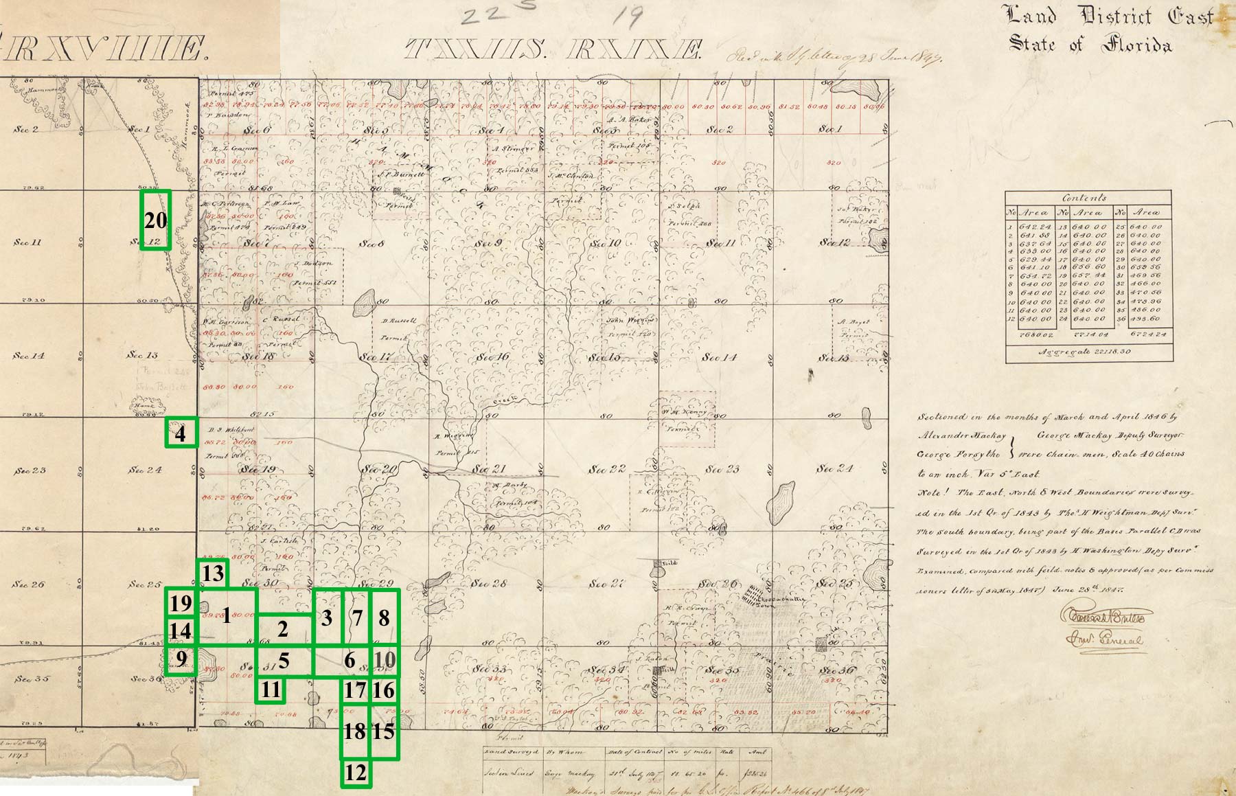
Perry G. Wall Land Patents (1,997 acres) in Hernando County, Florida
Click the Accession links to see the official land patent document at
BLM-GLO Records
|
Image |
Accession |
Names |
Date |
Twp - Rng |
Aliquots |
Sec. # |
County |
Acres |
Map Ref. |
 |
MW-1082-174 |
 WALL,
PERRY G, WALL,
PERRY G,
|
9/1/1851 |
022S - 019E |
SW¼ |
30 |
Hernando |
170 |
1 |
 |
MW-0600-227 |
WALL,
PERRY G,
|
11/10/1851 |
022S - 019E |
S½SE¼ |
30 |
Hernando |
80 |
2 |
|
022S - 019E |
W½SW¼ |
29 |
Hernando |
80 |
3 |
|
|
FL0350__.589 |
WALL,
PERRY G |
5/15/1852 |
022S - 018E |
NE¼NE¼ |
24 |
Hernando |
40 |
4 |
|
|
MW-0696-011 |
WALL,
PERRY G,
|
4/1/1854 |
022S - 019E |
N½NE¼ |
31 |
Hernando |
80 |
5 |
|
022S - 019E |
N½NW¼ |
32 |
Hernando |
80 |
6 |
|
|
MW-0696-366 |
WALL,
PERRY G,
|
4/1/1854 |
022S - 019E |
E½SW¼ |
29 |
Hernando |
80 |
7 |
|
022S - 019E |
W½SE¼ |
29 |
Hernando |
80 |
8 |
|
|
FL0360__.362 |
WALL,
PERRY G |
5/1/1855 |
022S - 018E |
NE¼NE¼ |
36 |
Hernando |
29 |
9 |
|
|
FL0380__.049 |
WALL,
PERRY G |
5/1/1855 |
022S - 019E |
NW¼NE¼ |
32 |
Hernando |
40 |
10 |
|
|
FL0950__.011 |
WALL,
PERRY G |
8/1/1860 |
022S - 019E |
SW¼NE¼ |
31 |
Hernando |
29 |
11 |
|
|
FL0950__.012 |
WALL,
PERRY G |
8/1/1860 |
023S - 019E |
NE¼NW¼ |
5 |
Hernando |
51 |
12 |
| |
FL0950__.013 |
WALL,
PERRY G |
8/1/1860 |
022S - 019E |
SW¼NW¼ |
30 |
Hernando |
45 |
13 |
|
|
FL0950__.015 |
WALL,
PERRY G |
8/1/1860 |
022S - 018E |
SE¼SE¼ |
25 |
Hernando |
40 |
14 |
|
|
FL0950__.060 |
WALL,
PERRY G |
8/1/1860 |
022S - 019E |
W½SE¼ |
32 |
Hernando |
36 |
15 |
|
|
MW-0392-086 |
WALL,
PERRY G,
|
8/15/1860 |
022S - 019E |
SW¼NE¼ |
32 |
Hernando |
40 |
16 |
|
022S - 019E |
SE¼NW¼ |
32 |
Hernando |
40 |
17 |
|
022S - 019E |
E½SW¼ |
32 |
Hernando |
37 |
18 |
|
|
FL0460__.299 |
WALL,
PERRY G |
3/10/1883 |
022S - 018E |
NE¼SE¼ |
25 |
Hernando |
40 |
19 |
|
|
FL0460__.365 |
WALL,
PERRY G |
3/10/1883 |
022S - 018E |
W½NE¼ |
12 |
Hernando |
80 |
20 |
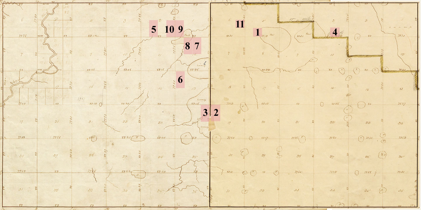
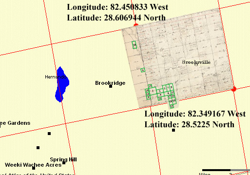
The map image at right shows Perry G. Wall's land patents
superimposed on
a modern day land survey map showing Township 22 South Ranges 18E and 19E |
 |