|
HAYDEN'S
FERRY CROSSING AT
JACKSON STREET
Students living in Tampa
would have taken the
ferry to get to Carter's
school house.
FERRY
CROSSINGS
BEFORE
HAYDEN -
1846: The
earliest
existing
records of
Hillsborough
Co.
Commissioner
meetings
History
of
Hillsborough
County,
Florida, Narrative
and
Biographical,
1928" by
Ernest L.
Robinson,
Director of
High Schools
of
Hillsborough
County,
Formerly
Principal
of Hillsborough
County High
School.
1846 -
Jan. 5: The
board
members, the
lost book of
1845, pay
and taxes
The first
meeting (for
which
records
still exist)
of the
Hillsborough
County
Commissioners
was held.
The board
consisted of
William
Hancock, M.C.
Brown,
Benjamin
Moody, Simon
Turman, and
James A.
Goff (not
present).
Simon Turman
was Judge of
Probate and
President of
the Board.
At this
meeting, a
small record
book of the
previous
year's
proceedings
was turned
over to the
board by
Manuel
Avilla,
former Clerk
of the
County
Court. This
book has
never been
found. Also
at this
meeting, pay
was
established
for the
board at $2
per day
while in
session.
The county
tax for 1846
was
established
at 50% of
the amount
assessed for
the State.
S.L.
Sparkman was
the tax
assessor and
John Parker
the tax
collector. |
|
1846 -
April 7:
Treasury
balance,
build a
courthouse
At this
meeting,
Thomas P.
Kennedy was
the
Treasurer of
the County
and reported
the balance
to be
$267.63. The
commissioners
were
appointed to
"superintend
the building
of a court
house and
other public
buildings in
the Village
of Tampa"
and
instructed
to "select
the spot of
ground for
the said
public
buildings,
make a plan
to start the
building and
finish them
as soon as
practicable
taking into
consideration
the funds on
hand..."
|
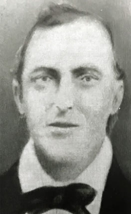 |
 THOMAS PUGH KENNEDY - Tampa City Council member THOMAS PUGH KENNEDY - Tampa City Council member
January 1849 – October 1850
M.G. Sikes, President
Jesse Carter
Thomas Pugh Kennedy
Culbreath A. Ramsey
William Ross
Born in Philadelphia on December 12, 1812, Thomas Pugh Kennedy moved to St. Augustine in 1828. He came to Fort Brooke in December of 1840 as a deputy U.S. Marshal. In 1843, he established a store at Tampa and Whiting Streets and traded with the Seminoles.
Photo and info from
The City Council of Tampa, etc. |
|
At the end of the First Seminole War, he purchased a schooner and engaged in trade with Central and South America. He served as Fort Brooke's Indian agent and was elected as the first Hillsborough County Treasurer in 1845 and took office in January of 1846. In 1848, he opened the Kennedy & Darling General Store, once the largest such store in South Florida, with future council member John Darling. He died in 1858. |
|
|
1846 -
May 23:
Establish a
ferry, build
a road
At this
meeting, Thomas Piper
was
granted "the
privilege of
establishing
a ferry
across the
Hillsborough
River at
Tampa." The
grant was to
last four
years and he
was to pay
five dollars
per year for
the last
three
years. The
ferry fees
were fixed
at five
cents per
man and
proportionately
higher for
vehicles. A
road was
authorized
to be
extended as
well. |
|
By James McKay, Jr. in "Reminiscences - History of Tampa in the Olden Days" Dec. 18, 1923
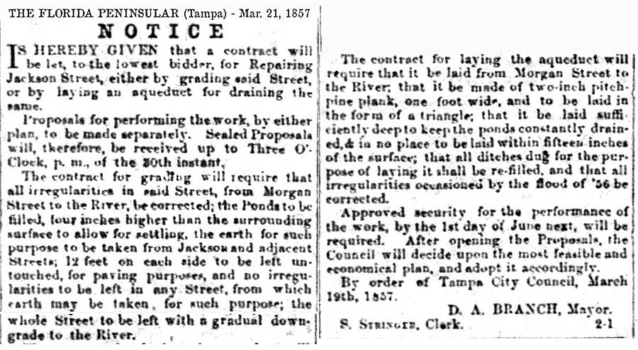
In 1852 we opened a ferry at the foot of Jackson street, so as to cross the stage with the mail. It was also used by the public. Ponds that were located on the east end of Jackson street caused the city officials as well as the people, considerable annoyance, especially during the rainy season. One of these ponds at the corner of Jackson and Marion street would take in all four corners and prevent pedestrians from passing in that direction. I have skated rocks over ice on this pond when it was frozen over during the winter.
The authorities dug a ditch in the center of Jackson street to drain these ponds, and in some places it was 12 feet deep. Across Franklin and Tampa streets small bridges were placed so as to permit passage of teams and the public. This did not accomplish what was desired so the ponds were filled in later on.
 |
|
|
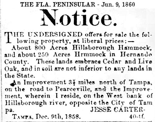
CARTER SELLS HIS LAND,
THE HAYDENS ARRIVE
In 1860, perhaps due to
the imminent secession
of Florida from the
Union and Civil War
looming, Jesse Carter
put up for sale his 800
acres of land in
Hillsborough Co. and 250
acres in Hernando Co. as
well as his improved
land 3½
miles north of Tampa and
the land on which he
currently resided, on
the west bank of the
Hillsborough River,
opposite the City of
Tampa.
The Haydens came to
Tampa in 1866 and soon
thereafter Jesse J. Hayden
bought some of Carter's
land where the school
was located and filed a
homestead claim for the
adjoining 60 acres. In
those years, the area
was known as Spanishtown
Creek. This was before
Obadiah Platt purchased
land here and created
Hyde Park.
Jesse's granddaughter
Marion A. McKay was born
in the school Oct. 8,
1875. In 1886 Henry B.
Plant bought the
property for his hotel.
He saved the School and
it was used as an
apothecary shop by Dr.
J. M. Grantham. In 1905
the Hotel was sold to
the City of Tampa. The
School was presented to
the DeSoto Chapter DAR
in 1931 by Mayor D. B.
McKay and City
Representatives. Jesse
and Susan’s daughter
Mattie married Donald S.
MacKay, son of sea
captain James McKay,
Sr., and later uncle of
Tampa mayor D.B. McKay.
The Jacksons and the
Haydens were among the
prominent families of
Old Tampa, and along
with the Haskins, owned
most of what would later
become Hyde Park. The
Haskins family, however,
sold their land before
Hyde Park was developed
because of the
inconvenience of
crossing the river with
children. H. B. Plant
later bought fifteen
acres on the west side
of the Hillsborough
River from the Hayden
family and in July 1888,
the Tampa Bay Hotel’s
cornerstone was laid.
|
The 1882
land
ownership
map below,
from the
Library of
Congress,
has been
enhanced
with color
to show
(yellow)
Jesse
Hayden's
property
where he
operated his
ferry.
The map was
drawn
showing
"Ferry" at
that
location.
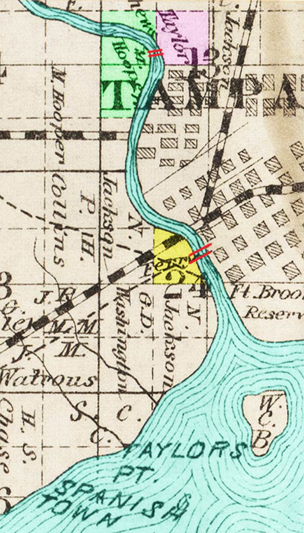
Further
north can be
seen where
Matthew
Hooper
operated his
ferry from
the west
bank of the
river.
Madam
Fortune
Taylor owned
the land on
the other
side, and
this later
became the
site of
Fortune
Street and
the bridge,
now named
the Fortune
Taylor
bridge in
her honor. |
|
TAMPA
CHARTERS
HAYDEN'S
FERRY
In March
1885, the
Tampa town
council
chartered
Hayden’s
ferry
crossing on
the river at
Jackson
Street,
stipulating
that "the
lessee of
any such
ferry shall
keep a good
ferry, flat,
capable of
ferrying
over safely
a six-mule
team and a
wagon loaded
with not
more than
5,000 pounds
weight,
stock
animals, and
goods across
the
Hillsborough,
and two good
skiff boats
for crossing
foot-passengers...He
shall put
across all
persons and
their
property at
any hour of
day or
night...After
9 o'clock
P.M. he may
charge
double
ferriage."
Hayden had
the right to
operate a
ferry, but
Tampa
reserved the
right to
build a
bridge
across the
river, free
or
otherwise.
The town was
growing.
Soon after
the railroad
arrived,
public and
private
interest in
a bridge
increased.
The
completion
of the
first
Lafayette
St. bridge
in 1889
would soon
put an end
to Hayden's
ferry
service.
|
|
|
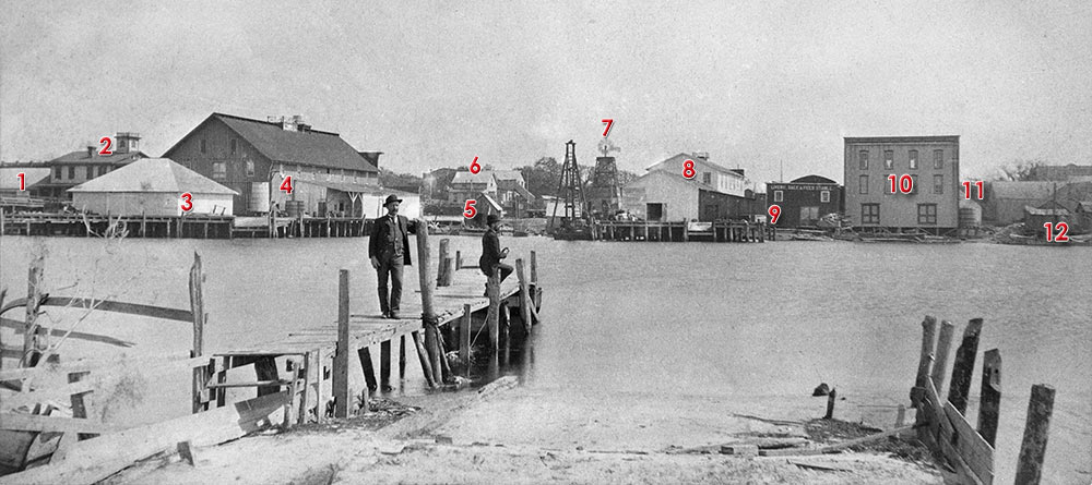
The photo below shows a
ferry crossing the
Hillsborough River.
The source doesn't give
the specific location
along the river and
provides very wide date
range of 1850 - 1930.
From the ROBERT N.
DENNIS COLLECTION OF
STEREOSCOPIC VIEWS (filtered
for Tampa) at The
New York Public
Library Digital
Collections.
The photo can be proven
to be a view of Hayden's
ferry crossing as seen
from the Hyde Park side
facing east looking at
the Tampa riverbank.
The photo
below is
from the
State
Archives
Florida
Memory
collection
and shows
the same
buildings
from a wider
view and the
same vantage
point from
across the
river.
Notice the
same 3-story
wood-frame
building at
the right of
the photo,
once again
viewed
directly
face-on.
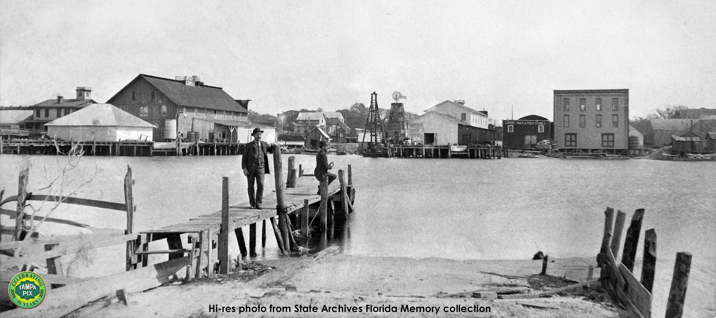
This
photo was most likely
taken sometime from 1890
to 1891. See the
1889 Sanborn map below
for explanation.
|
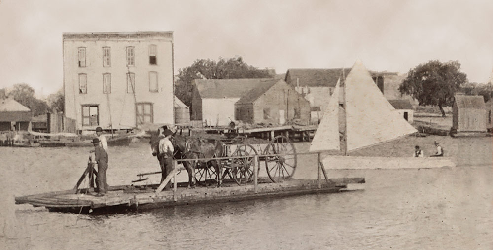
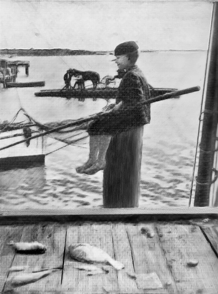
The photo at
right shows
a boy
sitting at a
pier on the
east bank of
the
Hillsborough
River,
facing town.
In the
background
can be seen
Hayden's
ferry
nearing
shore with a
horse and
carriage.
The grassy
islands
which became
Davis
Islands in
1925 are on
the horizon.
Image from
"Tampa Town,
1825 - 1886:
A Cracker
Village With
A Latin
Accent" by
Tony Pizzo,
1968
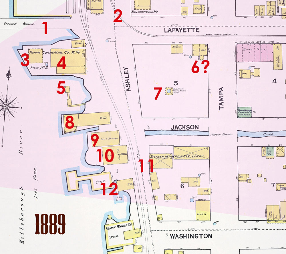
Proof of
which side
of the river
is being
viewed in
the above
photos can
be found on
this 1889
Sanborn map
below from
the
University
of Florida
digital maps
collection.
Notice the
3-story
wood-frame
building
(#10) is
a
warehouse/carriage
house.
The large
building at
the far left
of the State
Archives
photo above
is the Tampa
Commercial
Co.
warehouse
seen on Pier
No. 2 at the
map below as
#3 and #4.
Hayden's
ferry dock
can be seen
below just
above the
red arrow
|
 |
|
| |
|
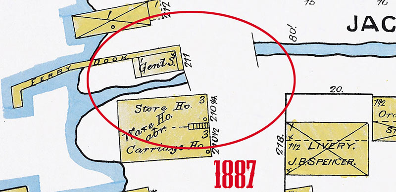
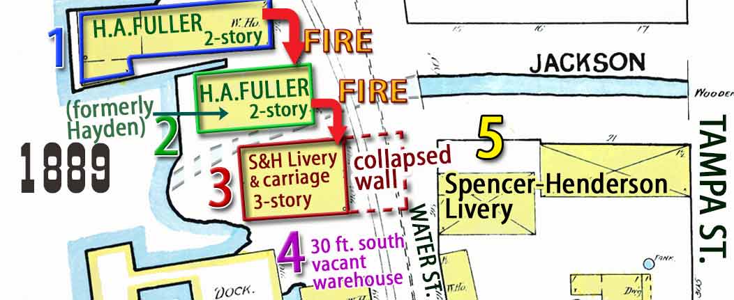
| The 1887 map of this area clearly shows Hayden's ferry dock on the north side of the Jackson St. ditch, which emptied into the river between the dock and the 3-story warehouse. |
|
 |
|
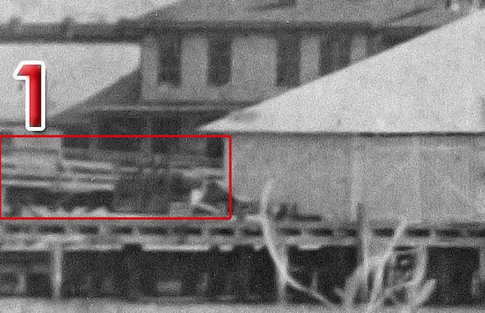
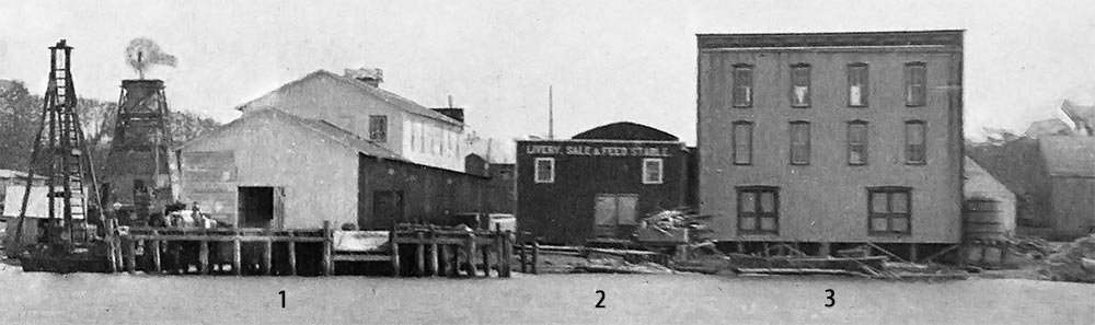
On the 1889 map above, the dock is no longer shown, the ditch drainage has been routed underground at Ashley St. and another general storage warehouse (#9) has been built where the ferry dock was located. This map most closely portrays this area as compared to the photo below.
PLACE YOUR CURSOR ON THE PHOTO BELOW TO SEE A CLOSE UP OF THE FERRY DOCK AREA. |
|
In the photo, the new warehouse at #9 has become a "LIVERY, SALE & FEED STABLE." |
At #1 can be seen the approach to the new wooden Lafayette St. bridge, which was opened in March 1889.
|
 |
On Dec. 21,
1890, a fire
destroyed
buildings 8, 9 &
10 in the above
photo.
They were at the
time, #1 H. A
Fuller 2-story
warehouse, #2 H.
A. Fuller
warehouse,
formerly Hayden
livery stable
and feed barn,
and #3 Spencer &
Henderson livery
and carriage
warehouse.
Read the article
about this great
fire.
|
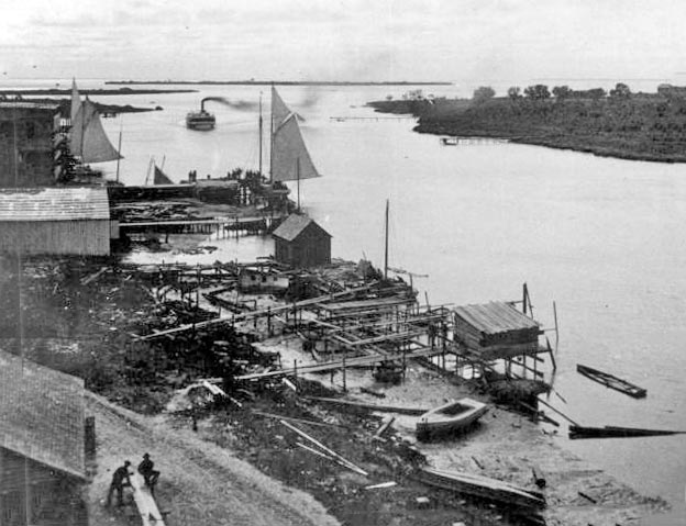
These two
images below
show the
same area of
Tampa's
riverfront
taken on the
Tampa side
around the
same time,
circa 1886.
The high
camera angle
in the photo
on the left
indicates it
may have
been taken
from the
rooftop of
the 3-story
warehouse
shown in the
above
images.
|
|
 |
Below, an
idealized
etching of
the same
view.
In both
images can
be seen the
undeveloped
area of
Spanishtown
Creek on the
right that
would become
Hyde Park.
The Platt
St. bridge
would be
built in
1926.
On the
horizon can
be seen the
mouth of the
Hillsborough
River with
the two
grassy
islands in
the bay at
far left.
In 1925,
dredging of
these
channels
would fill
them in and
become Davis
Islands.
 |
|
State
Archives of
Florida
Memory
collection
|
State
Archives of
Florida
Memory
collection
|
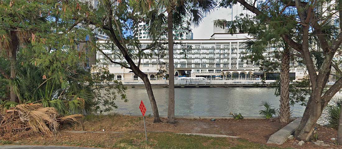
PRESENT-DAY VIEW OF
HAYDEN'S FERRY LOCATION
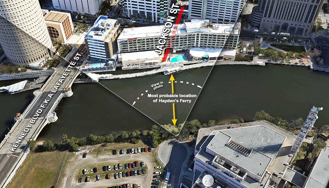
The
ground-level view today
is from 2 Kellar Street,
the cul-de-sac between
the NBC building and the
Kennedy Blvd. Bridge.
 |
|
|
|